Project Overview
Instrument and sampling strategies for NAFE were tested during a 2 weeks long trial campaign in a small monitored area, approximately 200km North-East of Adelaide,
South Australia. The objective of the test was mainly to set up the complex software component of the PLMR radiometer and to
investigate a number of issues related to the use of PLMR onboard the SERA aircraft, such as instrument attitude when mounted on the aircraft, calibration
procedures and aircraft related sources of noise for the radiometer. The airborne and ground sampling strategies proposed for NAFE were also tested.
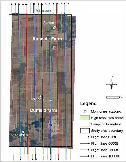
The study area was a semi-arid, generally flat agricultural area near the town of Waikerie, South Australia (see map on left).
The area was chosen due to its proximity to the Murray River and the presence of large irrigation areas, suitable for testing of the PLMR on wet soil
conditions and vegetation at advanced growth stage. Soils in the regions are mainly sandy, with some sandy loamy areas near the river. Land cover ranges
from agricultural to grazing, with patches of forest. The area covered by PLMR mapping was approximately 10km long and 6 km wide. Within this area, two
farms were selected for intensive soil moisture sampling. One was an agricultural farm with extensive wheat cultivations, distant from the river, and
was therefore chosen for his dry soil conditions ("Duffield" farm). The second one was a small farm in the north of the study area, presenting grazing and
small irrigated areas. This was chosen in order to capture wet soil conditions ("Auncote farm"). The farm were monitored with two permanent stations, measuring
in continuous near-surface soil moisture (0-5cm), soil temperature, thermal infrared “skin” temperature and rainfall. On every flying day, distributed
near surface soil moisture (0-5cm) measurements were taken on the ground at both farm, at two different resolutions, 250m covering the whole farm and
10m/5m at selected 150m x 150m high resolution areas. Supporting data such as vegetation biomass and water content, soil properties and surface roughness
were also collected.
|